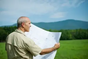
People often hear the term topographic survey at the start of a project. Architects ask for one before they prepare designs. Engineers rely on the information to plan drainage and structural work. Councils expect it before they assess an application. It sounds technical, but the idea behind it is simple. A topographic survey shows the land as it really is. It becomes the base layer for almost every planning and building decision.
At East West Surveyors, we complete topographic surveys across Sydney for homeowners, designers, and builders who want clear and reliable information before they move ahead. A good survey removes guesswork and helps a project start on solid ground.
What Topographic Surveys Are and What They Measure
A topographic survey, sometimes called a topographical survey, is a detailed record of the site’s natural shape and built features. It captures the slope of the land, high and low points, retaining walls, fences, driveways, steps, and any visible service points. The survey shows how the land behaves, where water flows, and how different parts of the site relate to one another.
Topographic surveying is the process used to collect this information. Surveyors measure ground levels, observe the terrain, and map features using precision instruments. The result is a plan that shows contours, spot levels, and everything on the site that may influence design or construction. It is a practical tool that guides architects, engineers, and councils through the early stages of a build.
The survey reflects the site as it exists now. This matters because older plans or online maps cannot capture small changes in height or features that affect real projects.
What These Surveys Typically Show
A topographic or topographical survey usually includes:
- spot levels across the site
- contours that show the slope
- the outline of existing buildings
- retaining walls and their heights
- fences and visible boundary indicators
- pits, drains, and stormwater features
- driveways, paths, stairs, and surface changes
- major trees and vegetation
- poles, surface markers, and visible utilities
- natural ridges, depressions, and water flow paths
This level of detail helps everyone understand the site’s constraints and opportunities before any design decisions are made.
Why Topographic Surveys Matter
Accurate land information influences the entire project. Designers need correct ground levels to plan floor heights, roof heights, and building placement. Engineers must understand the slope and drainage paths to design stormwater systems and retaining structures. Builders rely on the plan to estimate cut and fill, plan access, and understand how the site will behave once work begins.
Without a current survey, people often rely on assumptions. Those assumptions can lead to redesigns, additional costs, and delays during council approval. In many parts of Sydney, slopes, old infrastructure, and irregular sites mean reliable information is essential. A detailed survey from East West Surveyors reduces risks and supports better decision-making.
How Topographic Surveys Are Carried Out
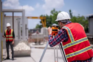
Topographic surveys follow a structured and practical method. Surveyors begin by establishing control points around the site. These control points ensure that all measurements relate to the same position and height. Once control is set, surveyors move through the property and collect ground levels at regular intervals. They observe the terrain carefully, identify natural high and low areas, and record all visible features.
To complete this work, surveyors use a mix of precise tools. This often includes gps topographic survey equipment, GNSS receivers, robotic total stations, and digital levels. Each instrument serves a purpose. GNSS is effective in open areas. Total stations are better near buildings and trees. Digital levels are used when height accuracy is critical. In some cases, laser scanners or drones are used to capture more complex surfaces.
After the fieldwork is complete, the measurements are processed in CAD or drafting software. The data is transformed into a clear plan with contours, levels, and features that designers can use with confidence. Professional judgement plays an important role. Surveyors decide which features are relevant, how to represent them, and the level of detail needed for the project.
Types of Topographic Surveys
Topographic surveys can vary in scope depending on the purpose of the project.
General topographic surveys
Used for planning, concept design, and early feasibility checks.
Detail and contour surveys
Feature surveys
Engineering topographic surveys
Laser scanning surveys
Read More about other types of Surveys
Topographic Surveys Compared with Other Survey Types
Topographic vs cadastral surveys
- A cadastral survey defines legal boundaries.
- A topographic survey shows terrain and features.
Both can be combined when a project needs boundary confirmation and ground detail.
Topographic vs hydrographic surveys
- Hydrographic surveys map underwater terrain.
- Topographic surveys map land surfaces.
The methods are similar, but the environments are different.
How Much a Topographic Survey Costs
The cost depends on site size, slope, vegetation, access, and the level of detail required.
Typical ranges include,
small residential lots: $800 to $1,500
standard Sydney blocks: $1,200 to $2,500
large or steep sites: $2,000 to $4,000 or more
The cost of topographical survey Brisbane sits within similar ranges. More detail, complex terrain, or tight contours can increase the cost. The value comes from reducing unexpected site issues and avoiding design changes later.
Learn more
When You Need a Topographical Survey
A topographical survey is often needed for:
- new home builds
- extensions and renovations
- development applications
- drainage and stormwater design
- landscaping plans
- earthworks and retaining walls
- subdivisions
- working with sloping or irregular land
Architects and engineers almost always request a current survey before they begin. It provides a reliable base that supports accurate design.
A Practical Checklist Before Ordering a Survey
To help the process run smoothly, clients can prepare by:
- confirming the purpose of the survey
- sharing old plans if available
- noting any access restrictions
- identifying visible utilities
- keeping the site reasonably clear for fieldwork
With this information, East West Surveyors can tailor the survey to the project needs.
Frequently Asked Questions
What is a topographical survey?
A detailed survey that maps the terrain and site features for planning and design.
How much does a topographic survey cost?
Most Sydney residential sites fall between $1,000 and $2,500.
What equipment is used in gps topographic survey equipment?
GNSS receivers, total stations, digital levels, scanners, and sometimes drones.
Does a survey include boundaries?
Only when a cadastral survey is requested as well.
What are topographic survey maps tarkov?
In the game Tarkov, maps show simplified height and terrain changes. This follows the same idea as real topographic maps, which use contours to show how land rises and falls.
Do I need a topographical survey?
Yes, if you are planning building or engineering work that depends on accurate site information.
Clear land information allows better planning and smoother construction. East West Surveyors provides topographic surveys that give homeowners, builders, and designers a reliable place to start.
Reach out to us to start your project!