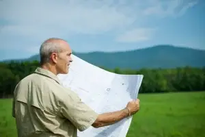
Buying or selling land in Western Sydney or Brisbane? Before you sign anything, you may need an identification survey. It’s a vital step that helps you understand exactly where your property starts and ends.
An identification survey is like tracing the borders of your land so you know precisely what you own. It protects you from legal problems, neighbour disputes, and costly mistakes later.
This guide explains what an identification survey is, when you need one, how it works, and how much it costs.
What Is an Identification Survey?
An identification survey, also known as a boundary identification survey, defines the true position of your property boundaries. It checks whether any fences, buildings, or structures sit outside or over those boundaries.
Licensed surveyors perform this work using specialised equipment and official land records. The survey confirms if the fences and visible markers match the legal title and helps identify any encroachments.
In simple terms, it is like placing pins around a picture frame so you know where the edges sit. The surveyor measures and marks the corners, verifies existing boundary lines, and prepares a detailed report and plan.
- Location of boundary pegs or markers.
- Any encroachments by neighbours or your own structures.
- Distances and angles between corners.
- Notes on easements, retaining walls, or fences near the boundary
When and Why You Need an Identification Survey
An identification survey protects your investment and helps avoid unnecessary conflict. Here are common reasons people arrange one:
- Buying or selling property
Banks, solicitors, and conveyancers often request a survey before settlement. It ensures there are no encroachments or legal disputes over boundaries. - Building or renovating
If you plan to build close to a boundary or add a fence, garage, or extension, a survey confirms you’re working within your land. - Subdividing land
Before dividing a property, the exact boundaries must be known and certified. - Resolving neighbour issues
A professional report can settle disputes about fence locations or overhanging structures. - Buying in growing regions
Western Sydney and Brisbane are high-growth areas. Rapid development, changing lot sizes, and new infrastructure make accurate surveys even more important.
Skipping this step can cause real problems. You might discover that part of your driveway or fence crosses into another property. That can lead to legal action or expensive rework. An identification survey provides peace of mind and legal certainty.
How the Process of an Identification Survey Works
Getting an identification survey is straightforward when you know the stages.
1. Pre-survey checks
Your surveyor starts by reviewing the property’s legal documents. They check the certificate of title, existing plans, and any easements or restrictions on the land. This ensures that the fieldwork matches official records.
2. On-site survey
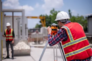
The licensed surveyor visits your property with precise GPS and total-station equipment. They locate existing pegs, fences, and structures. The surveyor measures distances, angles, and elevations to verify where the true boundaries sit.
During this step, they may place new boundary markers or flag existing ones. In urban areas like Western Sydney and Brisbane, this can include checking retaining walls, garages, and driveways near boundary lines.
3. Comparison and analysis
The field data is compared with your property title and historical survey plans. This identifies any differences or encroachments. The surveyor records if buildings, walls, or fences sit outside the legal boundary.
4. Report and plan preparation
After fieldwork, you receive:
- A survey plan showing the correct boundaries.
- An encroachment report highlighting any issues.
- Notes on easements, right-of-ways, and nearby features.
Your surveyor explains the findings and may recommend solutions. For example, they might suggest adjusting a fence or discussing shared boundaries with a neighbour.
5. Certification and storage
The report is certified by a Registered or Licensed Cadastral Surveyor. You can keep a digital copy for your solicitor, bank, or council. Having this official record helps with property sales and future building work.
Across NSW and QLD, local councils may also require the plan if you apply for building or subdivision approval.
How Much Does an Identification Survey Cost?
Typical cost range
- Western Sydney (NSW): about $1,000 – $3,000 for a standard suburban block.
- Brisbane (QLD): similar range, often $1,200 – $3,500 depending on access and lot complexity.
Large or irregular properties, sloping land, or sites with multiple structures can cost more.
What affects the price
- Size of the land – Bigger areas need more time and data points.
- Complexity – Properties with old or missing boundary markers take longer.
- Access – Tight urban lots or heavily fenced sites need extra setup.
- Purpose – Some reports include encroachment details, building set-outs, or legal diagrams.
- Location – Travel and local council conditions can slightly change fees.
Simple way to think about cost
An identification survey is like a health check for your land. The surveyor identifies any hidden issues before they turn into expensive problems. Spending a little now protects you from major costs later.
Choosing the Right Surveyor for an Identification Survey
Check credentials
Ask the right questions
- What is included in your quote?
- Will the boundary corners be pegged on site?
- How long will the work take?
- Can you provide both digital and printed copies of the report?
A professional surveyor should answer these clearly and explain any technical details in simple terms.
Why local experience matters
Why Identification Surveys Matter
Many property owners only discover boundary problems when they try to build or sell. A small measurement error can lead to serious delays or disputes.
An identification survey prevents these issues by:
- Confirming your land’s true boundaries.
- Identifying encroachments before they escalate.
- Ensuring compliance with planning laws.
- Supporting loan or insurance applications with accurate documents.
For developers, the report also helps coordinate trades, avoid rework, and ensure new structures meet setback requirements.
In fast-growing areas such as Western Sydney and Brisbane, where land values continue to rise, having reliable boundary information adds long-term value and peace of mind.
Working with East West Surveyors
- Reviewing your land title and existing plans.
- Conducting on-site measurements with the latest technology.
- Preparing a detailed plan and written report.
- Explaining findings in clear, everyday language.
Conclusion
An identification survey is one of the most effective ways to protect your property investment. It confirms the exact limits of your land, identifies potential problems, and ensures every building or structure sits where it should.
Before you buy, build, or subdivide in Western Sydney or Brisbane, talk to East West Surveyors. Our licensed professionals provide clear advice, accurate measurements, and detailed reports you can trust.
Get in touch today to arrange your identification survey and gain peace of mind knowing your property boundaries are correct.