If you’re an Australian homeowner thinking about putting up a fence, renovating, buying land or simply making sure your neighbour hasn’t accidentally claimed a few extra centimetres of your backyard, you’ve probably come across the term boundary survey. It sounds technical – and it is – but it doesn’t have to be confusing.
Here’s an in-depth, easy-to-read guide in clear Aussie language, breaking down exactly what a boundary survey is, why you might need one, how it works and what to look out for. No jargon overload, no keyword stuffing – just practical info that helps you protect your biggest asset.
What is a boundary survey?
A boundary survey is a specialised type of land survey carried out by a licensed surveyor to precisely establish the legal boundaries of a property. It determines exactly where your land starts and ends, based on official records, title documentation and physical evidence on the ground.
In other words:
A boundary survey answers the question, “Where are my property lines, exactly?”
It involves locating or re-establishing boundary corners, measuring the site, checking for encroachments and marking the edges of the property. The end result is a formal plan or diagram confirming your boundaries with legal accuracy.
Some states call it a “boundary identification survey” or “title re-establishment survey”, but the purpose is generally the same across Australia.
Why would you need a boundary survey?
Boundary surveys are more common than people realise, and they can prevent expensive mistakes, neighbour disputes, council headaches and legal drama. Here are the main reasons homeowners get one:
1. Building or Renovating
If you’re installing a fence, building a shed, putting in a pool, adding an extension or upgrading your home in any way, you’ll want to know your boundaries. Councils often require accurate siting plans, and you don’t want a new fence accidentally sitting on the wrong side of the line.
2. Avoiding Neighbour Disputes
Many property disagreements start with an assumption – like thinking a fence is in the right spot when it isn’t. A boundary survey removes guesswork and provides clear, defensible evidence of where the line truly sits.
3. Buying or Selling Property
When purchasing land or a home, a boundary survey gives you clarity about what you’re buying and whether there are any issues like encroachments or missing boundary markers. Sellers also benefit from providing buyers with accurate information.
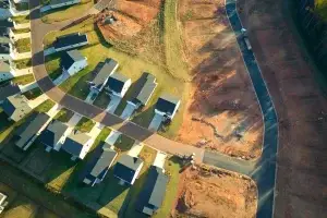
4. Subdivision and Development
If you’re planning to subdivide, redevelop or build multi-dwelling units, you will absolutely need a boundary survey. Councils require precise boundary data to approve subdivision plans and building locations.
5. Missing, Moved or Damaged Boundary Pegs
Boundary markers can get buried, removed, damaged or shifted over the years. A surveyor can re-establish them to keep the property’s description accurate and avoid future confusion.
6. Peace of Mind
Even if you’re not building anything, many homeowners simply want the certainty that the land they think is theirs actually is.
How does a boundary survey work?
While the exact process varies by surveyor and state, most boundary surveys in Australia follow several core steps:
1. Research and Document Review
The surveyor begins by gathering all available records, such as:
- Title documents
- Previous survey plans
- Subdivision plans
- Land registry information
- Easements, restrictions and covenants
This forms the legal basis for determining the correct boundaries.
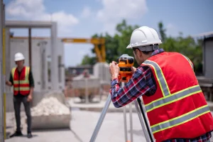
2. Field Inspection and Measurements
Next, the surveyor visits your property to locate physical evidence and measure the land. They may use tools like GPS equipment, total stations, laser scanners and high accuracy measuring devices.
During this stage, they check for:
- Existing boundary pegs or markers
- Fences and retaining walls
- Neighbouring structures
- Possible encroachments
- Differences between the current layout and legal boundaries
They’ll also compare what’s physically on the ground with the old plans and title documentation.
3. Re-establishing Boundary Marks
If required, the surveyor will place new pegs or stakes to clearly mark the corners and lines of the property. This is often called “pegging out” the boundary.
These markers help builders, fence installers and homeowners visually understand the property limits.
4. Preparing the Survey Plan or Report
Once the measurements and boundary positions are confirmed, the surveyor prepares a formal plan. This document typically includes:
- Accurate boundary lines
- Property dimensions
- Any encroachments
- The position of structures relative to the boundary
- Notes about easements or limitations
- Diagrams and reference information
This final plan is legally recognised and can be used in building approvals, legal matters, sales contracts and more.
5. Lodgement (if applicable)
For subdivisions or significant boundary adjustments, the plan may need to be lodged with your state or territory’s land registry office. This isn’t necessary for all surveys, but your surveyor will guide you.
What’s included - and what isn’t
Boundary surveys can vary in detail depending on what you request, so it’s worth understanding what’s typically included and what may require an additional service.
Usually included
- Identification and marking of legal boundaries
- Location of existing structures relative to boundaries
- Detection of encroachments
- Confirmation of corner markers
- A formal boundary survey plan
Not usually included (unless you ask)
- Detailed topographic information (contours, levels)
- Utility locations (water, sewer, electrical)
- Full architectural site plans
- Soil testing or geotechnical analysis
- Council approval applications
If you need more than a simple boundary definition, make sure you clarify your scope before booking.
Tips for homeowners
Here are some practical things to know before booking a boundary survey:
1. Make sure your surveyor is licensed
Make sure your surveyor is licensed. Only a registered or licensed surveyor can legally certify property boundaries in Australia, and this ensures the work meets legal standards. If you want a clearer idea of a surveyor’s role and responsibilities, you can read our related guide What Does a Surveyor Do to understand how they support property owners and builders.
2. Ask exactly what the quote includes
Some surveys include peg-marking, others don’t. Some provide a full plan, others only a partial report. Clarifying early avoids surprises.
3. Allow time in your project timeline
Boundary surveys, especially for tricky or older sites, can take time – sometimes several days or weeks depending on complexity.
4. Talk to your neighbours if required
Surveyors sometimes need access to adjoining properties, especially to inspect fences or markers. Giving neighbours a heads-up avoids tension.
5. Keep your survey plan safe
A boundary survey plan is an important legal document. Store it somewhere secure, because you may need it again for building, selling or resolving future issues.
State-by-state quirks
Each Australian state and territory has its own rules and terminology. For example:
- Queensland relies heavily on visible survey pegs to define property corners.
- Victoria often uses the term “re-establishment survey.”
- NSW requires that only registered surveyors perform cadastral (boundary) work.
- Some states have unique lodgement requirements for subdivision plans.
Your surveyor will be familiar with the regulations in your area.
Is a boundary survey worth it?
Absolutely. With the potential for costly disputes, council issues or even having to move a structure that was built in the wrong spot, a boundary survey is a smart safeguard.
It gives you:
- Legal certainty
- Protection during construction
- Confidence during buying or selling
- Clarity for future plans
- Peace of mind
For many homeowners, it becomes the single most valuable document they have when dealing with property improvements or neighbour concerns.
If you want a clear understanding of your property limits,
East West Surveyors can help. Our licensed team provides accurate boundary surveys for homeowners, buyers and builders across Australia. Reach out today to request a quote or speak with a surveyor who can guide you through the next steps.